venerdì 5 settembre 2014

Mistero: Il cratere nello Utah che sconcerta i geologi- Mystery: The crater in Utah that baffles geologists


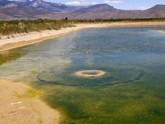
Gary Dalton stava svuotando lo stagno di irrigazione sul suo terreno agricolo in Circleville, Utah, quando ha fatto una scoperta sorprendente: un cratere gigante sul fondo del bacino. "Il sole era in alto, così ho visto questa formazione che nessuno aveva mai visto", dice a KSL.com . Il foro , rienpito di alghe, misura circa 25 metri di diametro  almeno 7 cm di profondità al centro, la cosa ha sconcertato non solo i media ma anche i geologi di tutti gli USA. "Abbiamo diverse teorie ... [ma] la maggior parte si sono rivelate sbagliate", dice uno scienziato del Geological Survey Utah. Le possibilità avevano incluso una sorgente naturale emersa da sotto il bacino, una conduttura sepolta, un terremoto, una meteora, o un pozzo di metano , ma essi o non sembrano geograficamente probabili o sono stati esclusi con prove fotografiche.

In siberia circa 2 mesi fa  un evento simile si è verificato, anche se in quel caso i crateri erano enormemente più profondi. il mistero si infittisce.....
---English Version---
Gary Dalton was emptying the irrigation pond on his farm land in Circleville, Utah, when he made ​​a startling discovery: a giant crater at the bottom of the basin.  "The sun was high, so I saw this formation that nobody had ever seen," he tells KSL.com. The hole, rienpito algae, measuring about 25 meters in diameter at least
7 inches deep at the center, it has baffled not only the media but also the geologists of the USA.
"We have several theories ... [but] most have been proven wrong," says a scientist at the Utah Geological Survey. The possibilities had included a source Natural emerged from beneath the basin, a buried pipeline, an earthquake, a meteor, or a well of methane, but they either do not seem likely or have been geographically except with photographic evidence.  In Siberia about 2 months ago a similar event occurred, although in that case the craters were vastly deeper. the mystery deepens .....

lunedì 1 settembre 2014

Mistero delle pietre: Risolto - Mystery of the stones: Solved

Un team di ricercatori è finalmente riuscito a spiegare come tali grandi massi possono muoversi da soli.
Il fenomeno, che è stato scoperto nel 1940, è relativo al movimento inspiegabile di massi molto pesanti, anche 320 kg, in un letto asciutto del lago situato nel Death Valley National Park. Nessuno ha mai visto i massi che si muovono direttamente, ma lunghe scie lasciate dietro di loro nella sabbia sembrano suggerire che i sassi si muovano in qualche modo su distanze significative da soli. Nel tentativo di risolvere il mistero una volta per tutte un team di scienziati provenienti da Scripps Institution of Oceanography  ha visitato il sito nel 2011 e istituito una stazione ad alta risoluzione meteo , monitorando 15 roccie con dispositivi GPS , necessari per misurare movimenti micrometrici. Dopo due anni , durante una visita al sito nel dicembre 2013 il team ha scoperto che la zona era stata sommersa in 3 pollici di acqua. Si è giunti alla conclusione che il
movimento delle roccie è dovuto al parziale allagamento della zona, il fenomeno avviene solo in particolari condizioni , ovvero quando le roccie vengono parzialmente coperte dall'acqua piovana. Il movimento è la combinazione di questo elemento  con l'azione del vento e con il conseguente congelamento dell'acqua durante la notte e lo scioglimento del ghiaccio al sole caldo durante il giorno.

 "E 'possibile che i turisti abbiano  effettivamente visto che questo accade senza rendersene conto", ha detto il co-autore Jim Norris.  "E 'davvero difficile da misurare che una roccia è in movimento se tutte le rocce intorno ad esso si stanno muovendo!"
---English Version---
A team of researchers has finally managed to explain how these large boulders to move independently.
The phenomenon, which was discovered in 1940, is relative to the unexplained movement of boulders very heavy, even 320 kg, in a dry lake bed located in Death Valley National Park. No one has ever seen the boulders that move directly, but leave long trails behind them in the sand seem to suggest that the rocks move in some way over significant distances by themselves. In an attempt to solve the mystery once and for all a team of scientists from Scripps Institution of Oceanography has visited the site in 2011 and established a high-resolution weather station, monitoring 15 rocks with GPS devices, needed to measure micrometric movements. After two years, during a visit to the site in December 2013, the team found that the area had been submerged in 3 inches of water. It has come to the conclusion that the
movement of the rocks is due to the partial flooding of the area, the phenomenon occurs only under specific conditions, ie, when the rocks are partially covered by rainwater. The movement is the combination of this element with the action of the wind and the consequent freezing of the water during the night and the ice to melt in the hot sun during the day. "It 's possible that tourists have actually seen this happen without realizing it," said co-author Jim Norris.
  "It 's really hard to measure that a rock is in motion if all the rocks around it are moving!"